


 57 Huynh Thuc Khang - Dong Da - Hanoi

 02435533388
 vnptit@vnpt.vn


 Contact
For vast, fragmented production areas, updating crop status often takes a lot of time and manpower. Connecting unmanned aerial vehicles (UAV), AI technology, and the VNPT Green agricultural ecosystem, VNPT is developing a solution to integrate aerial survey data into production management processes.
From UAV imagery to growing area information
For production areas that are large or have complex terrain, manual surveys struggle to meet the requirements for regular updates. Using unmanned aerial vehicles (UAV) helps collect imagery from above. However, utilizing these images for production management requires tools for processing, analysis, and linking with related data. This is the problem that VNPT aims to solve when developing the VNPT UAV Platform—a platform for managing and leveraging UAV data, combining AI technology and designed to integrate with the VNPT Green agricultural ecosystem.
Instead of organizing individual flights and then processing data with various tools, the VNPT UAV Platform aims to provide unified management across the entire process—from flight planning, mission organization, and device management to collecting, processing, and displaying results on digital maps. Data is centrally organized and can be searched by area and time, as well as compared across different survey periods. The analysis stage is where AI comes in to process image data collected from UAV. Depending on the integrated model and the specific requirements of each task, the system can identify objects, classify conditions, detect anomalies, and present the results as visual information layers on the map.
In crop monitoring, AI combines data from appropriate sensors to analyze vegetation indices NDVI, helping to identify variations in plant growth and pinpoint areas requiring inspection. These results assist technical personnel in identifying spots needing attention, though they are not sufficient on their own to conclude pests, diseases, or the root causes of anomalies without cross-referencing specialized data and conducting field inspections. Data stored across survey flights also helps monitor changes in planting areas, effectively serving production management.
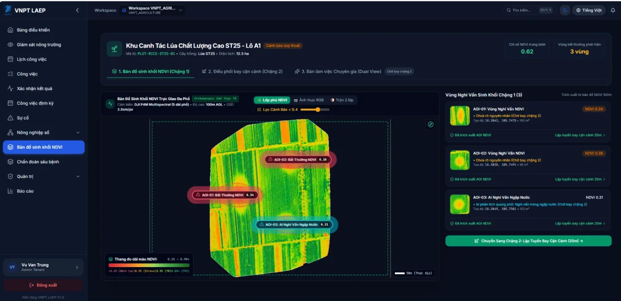
Figure: 1 – Biomass map NDVI
To meet diverse operational needs, the VNPT UAV Platform is developed with a focus on: process automation, AI integration, building a shared platform, and supporting multi-device and multi-purpose operations. The platform aims to connect multiple UAV models, sensors, and mission configurations, serving tasks such as crop area mapping, growth monitoring, anomaly detection, infrastructure inspection, and field data exploitation. This organizational approach enables data from flight missions to be managed and utilized within a unified workflow, rather than being fragmented across individual devices or survey missions.
Connecting UAV data with the VNPT Green agricultural ecosystem
While UAV provides imagery and AI supports status analysis, connecting with specialized management systems will expand data utilization in production activities. Following this direction, the VNPT UAV Platform is developed to integrate with the VNPT Green ecosystem. Visual and spatial data collected from UAV is processed, analyzed, and displayed on digital maps. Specialized systems can leverage the results to manage planting areas, monitor production, and support operations.
In planting area management, UAV data can assist in constructing status maps, recording boundaries and areas according to survey results, and tracking changes over time. When integrated with management records, this information provides an additional basis for cross-checking, verification, and report compiling, while not replacing legal records or data certified by competent authorities.
For production monitoring, combining multispectral imagery with weather data, soil data, and cultivation information can help identify areas with anomalous growth and isolate areas suspected of pests, diseases, or uneven development. Based on inspection results and expert assessments, managers have additional information to consider suitable plans for water, fertilizer, and resource usage tailored to each specific area.
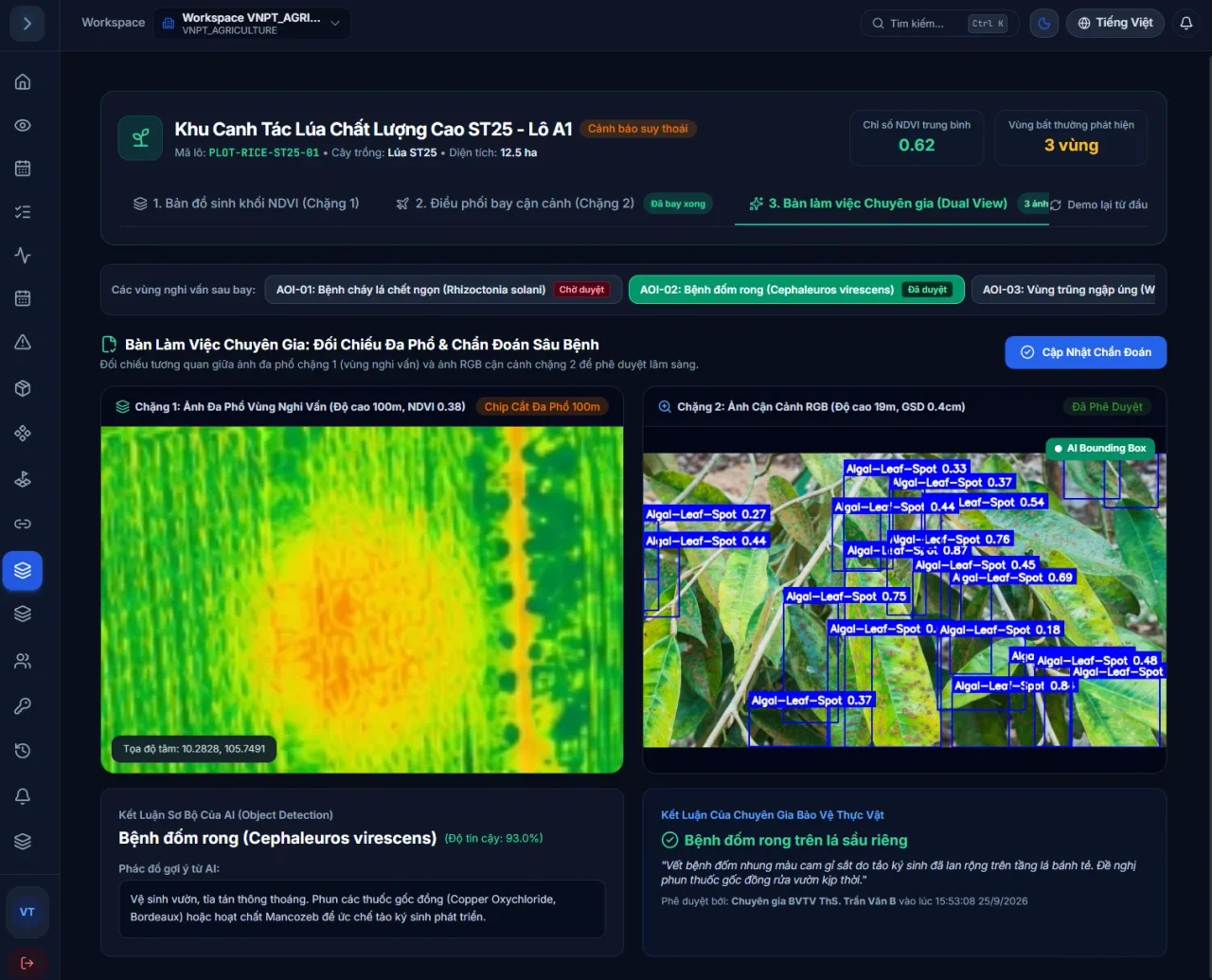
Figure: 2 – Pest and disease identification using AI
Another application direction is adding spatial data to the agricultural product traceability process. Growing area maps, survey histories, and recorded changes can be linked with production records, farming logs, and supply chain data, supporting cross-checking and information transparency among relevant parties. Complete traceability still depends on the connection of authorized records and data sources.
In its next development phase, VNPT UAV Platform will continue to expand its capability to integrate devices, sensors, AI models, and specialized data; standardize the process from flight organization to report synthesis, while improving the centralized data management and access control mechanisms.
From collecting images using UAV to analyzing with AI and connecting to VNPT Green, the solution is developed to form a seamless data pipeline capable of serving multiple agricultural management tasks. The notable aspect lies not in having an additional survey tool, but in the ability to bring field data into the production management system so that information is updated, cross-referenced, and utilized when making decisions.