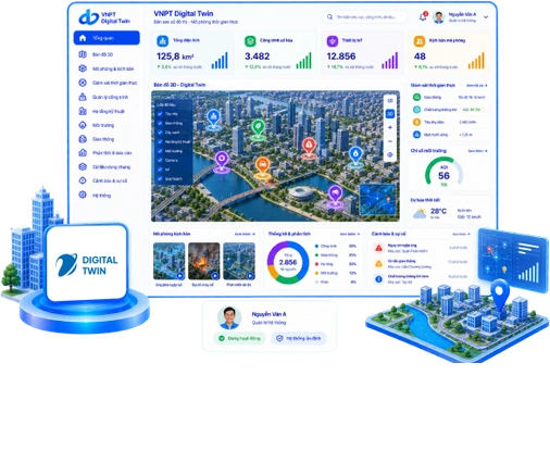
VNPT Digital Twin

Digital twin for smart cities

VNPT Digital Twin is an urban digital twin platform featuring technology developed in-house by VNPT; it recreates 3D urban spaces using GIS, BIM, UAV, 3D scanning, and real-time IoT data to enable simulation, analysis, forecasting, and decision support.

artwork

Key advantages

Operational cost optimization

A shared spatial data model reduces the need for surveys, measurements, monitoring, and manual labor.

Simulation-based decision-making

Multi-scenario simulations help assess impacts, minimize errors, and reduce risks.

Multi-dimensional urban management

Visualizes aerial, ground-level, and underground spaces within a unified 3D model.

Near real-time data

Integrates infrastructure, structures, transportation, and planning on a shared data platform.

Key features

Interface 3D GIS/CIM data collection and management for VNPT Digital Twin

3D GIS/CIM data collection and management

  • Digitizes maps, 3D models, VR360 views, POIs, and descriptive data.
  • Manages planning, structures, infrastructure, data versions, and history.
Interface Urban order monitoring for VNPT Digital Twin

Urban order monitoring

  • Collects field data via mobile devices and detects changes or unauthorized construction.
  • Alert and incident management, response coordination, and KPI reporting.
Interface Virtual model and visual operations management. for VNPT Digital Twin

Virtual model and visual operations management.

  • Measurement of distance, area, and height on 3D models; VR360 tours.
  • Integration of IoT, AI cameras, specialized systems, and operational dashboards.

Why choose VNPT Digital Twin

Management via 3D models.

Consolidation of multi-sector data; visualization of urban status and changes.
Digitized regulatory management.

Early violation detection, end-to-end management, and simulation of resolution plans.

Transparency and digital experiences.

Lookup of planning, infrastructure, and projects; VR360 experiences for tourism and heritage sites.

Customers

Customer groups

  • Government/urban authorities: Provincial/city People's Committees, Departments of Construction, Science and Technology, Natural Resources and Environment, and Culture and Tourism, special zones and industrial parks (for urban Digital Twin, planning, traffic, flooding, environment, urban infrastructure and 3D maps for virtual tourism).
  • Industrial parks/logistics: Industrial park management boards, factories, warehouses, ports and logistics operators (for Digital Twin management and monitoring of infrastructure, assets and the environment).
  • Real estate/private urban areas: Developers of urban areas, resorts and mixed-use complexes (for smart urban Digital Twin and 3D virtual models of urban areas to introduce projects and attract investors).

Contact information

Multi-sector Digital Data Solutions (MDS) Center.