


 57 Huynh Thuc Khang - Dong Da - Hanoi

 02435533388
 vnptit@vnpt.vn


 Contact
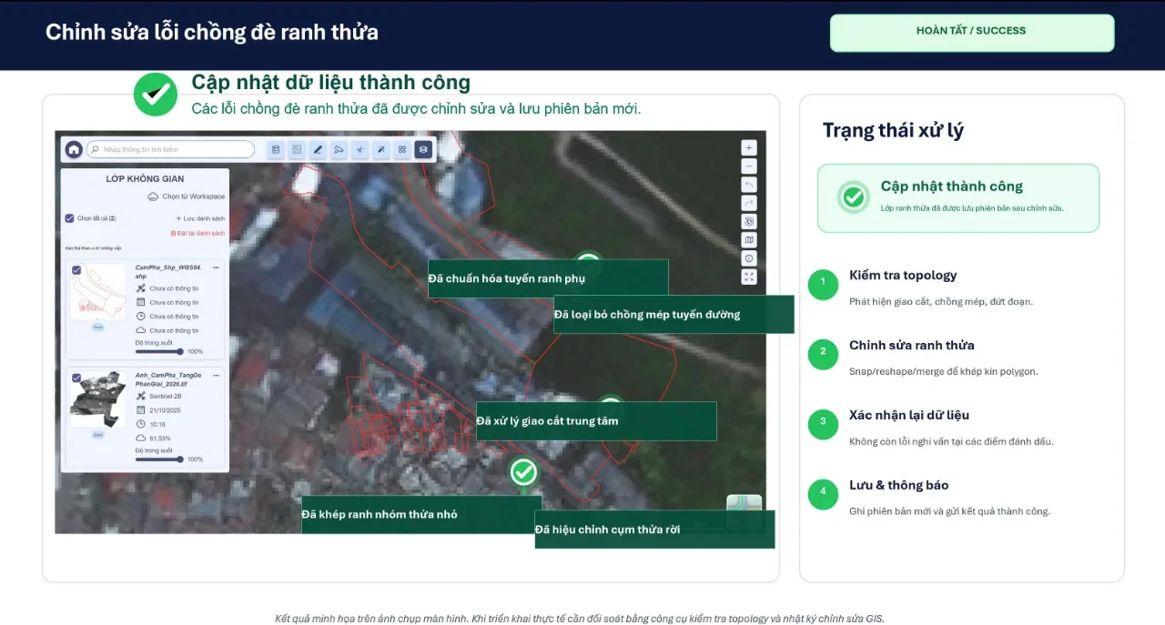
Faced with a massive volume of land data requiring review, accurately identifying abnormal areas to concentrate processing resources is an urgent requirement. VNPT Group has integrated satellite imagery, UAV, and geospatial artificial intelligence (GeoAI) into the management system, creating an end-to-end process from detection and cross-checking to data updating.
"Digitizing" and controlling land data spatially
A complete land database does not just stop at attribute information or paper records, but more importantly must accurately reflect the location and geometric boundaries of each land parcel on the ground. Therefore, data cleansing must simultaneously verify both legal records and spatial data.
If spatial error processing is skipped, the system will still contain critical errors such as overlapping land parcels, misaligned locations, or inability to link with cadastral records. Introducing advanced technology into the process helps specialized officers promptly identify anomalous zones for targeted handling.
This model leverages the wide-area view of satellite imagery to monitor land fluctuations; uses UAV to capture detailed images of key areas; and simultaneously uses cadastral records and ground verification results as the decisive legal basis. The combination of automated image processing and AI helps rapidly filter huge volumes of data, instantly delivering suspicious points to operators.
This approach helps functional agencies transition from widespread inspections to targeted zoning, optimizing resources. For areas lacking mapping data, technology imagery will support initial surveying and data preparation. Even so, technology images only reflect current surface status; the official legal validity of a land parcel remains completely dependent on official records and appraisal by competent authorities.
End-to-end process from review to progress control
To integrate technology deeply into operations, VNPT integrated the VNPT iLIS system with an execution portal that provides end-to-end support for building the land database. Among them, VNPT iLIS serves as the core platform supporting cadastral data management, change registration, certificate issuance, dossier circulation, and information connectivity, thanks to integrated GIS parcel boundary editing map tools. Accompanying VNPT iLIS, the execution portal supports end-to-end detailed management across the entire workflow chain: from receiving, taking inventory of source documents, quality classification, digitization, standardization, and linking dossiers to land parcels, to spatial data verification and pushing clean data into the system.
In the spatial review stage, the system overlays parcel boundary layers onto satellite imagery to automatically flag common errors: overlapping parcel boundaries, small parcels misaligned with boundaries, parcel boundaries overlapping roads, or shifted parcel groups. In cases where satellite imagery lacks clarity, UAV devices are deployed to capture detailed footage of parcel edges, structures, roads, etc., helping the working group thoroughly prepare beforehand and avoiding repeated field trips.
Based on records and verification results, officers perform technical operations on the system to align boundaries, split or merge fragmented parcels, or adjust overlapping areas. Notably, the operational dashboard also functions as an intuitive progress management tool. The system continuously updates the number of received applications, completed cases, and backlog lists complete with reasons and specific individual responsibilities. As a result, leadership can easily monitor progress and promptly allocate resources to sluggish "bottlenecks".
The solution from VNPT not only helps shorten individual processing times but also creates a tightly connected pipeline: from anomaly detection and record cross-referencing to technical processing, verification, and updates. Upon completion, data accuracy will be consistently maintained through the synergy between periodic satellite imagery and regular land change registration activities.